 Heywood (pop. 28,000) is a town within the Metropolitan Borough of Rochdale, in Greater Manchester, England. It lies on the south bank of the River Roch and is 2.4 miles (3.9 km) east of Bury, 3.7 miles (6.0 km) west-southwest of Rochdale, and 7.4 miles (11.9 km) north of the city of Manchester. The town of Middleton lies to the south, whilst to the north is the Cheesden Valley, open moorland, and the Pennines. Heywood's nickname is Monkey Town, a name with unclear origin, but known to date as far back as 1857.
During the Middle Ages the area was thinly populated and consisted of several hamlets. Apart from the Heywoods of Heywood Hall, the sparse population of Heywood comprised a small community of farmers, most of whom were involved with pasture but supplemented their incomes by weaving woollens and fustians in the domestic system. During the Early Modern period, the weavers of Heywood had been using spinning wheels in makeshift weavers' cottages, but as the demand for cotton goods increased and the technology of cotton-spinning machinery improved during the early 18th century, the need for larger structures to house bigger and more efficient equipment became apparent.
 Industrial textile manufacture was introduced in the town in the late 18th century and the first spinning-mill - Makin Mill - was built at Wrigley Brook (later known as Queens Park Road)
This initiated a process of urbanisation and socioeconomic transformation in the area and the population moved away from farming, adopting employment in the factory system.
The cotton-trade in Heywood grew, and by 1833 there were 27 cotton mills. In the 20th century, the town's cotton mills went into steep decline, only Glossop in Derbyshire went into sharper recession; in contrast, the spinning capacity of nearby Rochdale shrank more slowly than any other mill-town apart from Wigan.
Imports of foreign cotton goods during the mid-20th century precipitated the decline of Heywood's textile and mining industries, although this resulted in a more diverse industrial pattern.
Economically, Heywood is supported by its proximity to junction 19 of the M62 motorway, which provides transport links for large distribution parks in the south of the town.
The town had its own canal, the Heywood Branch Canal which is now infilled and largely gone.
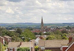
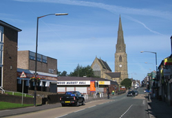 The Parish Church of St Luke the Evangelist is Heywood's major landmark - the focal point of the town centre. A place of worship at the site of St Luke's is known to have existed prior to 1611.
The Old Heywood Chapel was demolished in 1859 to make way for a new church building in the design of Joseph Clarke. The foundation stone of what is now the present church building was laid on 31 May 1860, and was completed in 1862 using stone from Yorkshire and ashlar from Staffordshire and Bath.
St Luke's was consecrated on 8 October 1862 following a public subscription appeal, and dedicated to Luke the Evangelist. The tower and spire is detached from the main church building and stands 188 feet (57 m) high, dominating Heywood's centre and townscape.
In 2007 plans were announced to shake off an area's 'mill town' image and rejuvenate the town over a 10-15-year period to appeal to a younger generation. The plan involves creating new retail, business, and community spaces, demolishing 300 flats and houses and replacing them with 1,000 new homes.
Queens Park in Heywood has recently undergone a multi-million pound facelift with many of its Victorian attractions restored such as the old fountain and many of the statues. It was officially 're-opened' in June 2006.
Ashworth Valley is a renowned local beauty spot.
Written by: Alex Bettucchi & Cristina Solenni - August 2010